Winster & Gilpin Habitat Improvement
We have been working on a 4 year project to assess the current status of the Winster and Gilpin catchments, identify opportunities to enhance and restore areas and where appropriate and implement restoration/remediation options to allow for recovery. SCRT have developed close links with the community; working with landowners to identify opportunities, working with communities to undertake monitoring and develop options and running a number of events for schools, children and adults alike to get involved with the world of rivers.
The project focussed on the catchments of Winster and Gilpin, both catchments have sources near Bowness on Windermere and Crook, draining into the Kent Estuary. The rivers flow through predominantly fell land and rough grazing pasture, and the catchments are sparsely forested. Historic and current channel maintenance has resulted in sections of heavily modified river and a lack of habitat. This is particularly true for the Lyth Valley, in the lower Gilpin catchment. Within this area it is currently proposed to establish an Internal Drainage Board to maintain the watercourses. This fell outside the scope of the project which focused in the upper Gilpin catchment.
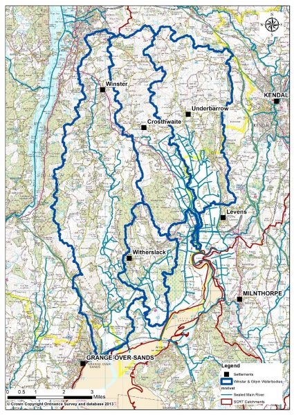
Map 1 – Winster and Gilpin waterbody catchments. (Note the project will only focus on the upper Gilpin catchment)
Environment Agency monitoring had shown a deterioration since 2015 in the classification of the River Winster under the Water Framework Directive. This Directive requires us to meet ‘Good’ ecological status under European Law by 2021. This decline has been attributed to poor dissolved oxygen concentrations. Similarly, the Gilpin is also failing to meet ‘Good’ Ecological status.
Table 1. Water body classification – River Winster:
| 2015 | 2016 | |
| Overall Water Body | Good | Moderate |
| Ecological | Good | Moderate |
| Chemical | Good | Good |
Table 2. Water body classification – River Gilpin:
| 2015 | 2016 | |
| Overall Water Body | Moderate | Moderate |
| Ecological | Moderate | Moderate |
| Chemical | Good | Good |
However, it’s not just Environment Agency data which shows us there has been deteriorations, residents of both valleys provide accounts of drastic reductions in fish densities.
In the initial year of the project we undertook a data review and evidence gathering exercise. This enabled us to understand the current situation and provide a baseline for any future work. This included:
- Comparisons of local and national fish trends
- Assessments of riparian shade density
- Identification of barriers to fish migration
- Analysis of existing monitoring data
We began to undertake our own monitoring supported by volunteers, including fish and riverfly surveys, please see our monitoring section for more information.
This would then help us to identify opportunities for habitat improvement to really make a difference in the valleys. Possible options included:
- Establishing riparian buffer strips to reduce bank erosion and intercept surface run-off and silt
- Installing large woody debris to create habitat diversity
- Investigating options to remove or modify man-made barriers to fish migration
- Tree planting in areas where canopy cover is limited to ‘keep rivers cool’ for fish
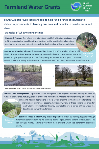
In support of all of this we were looking to make this a community project, working with local schools to run events and family days, and offering support to landowners to deliver some of these improvements. Some examples of the funding available for landowners are shown here:
Project Update
Following the initial year of investigations, we have a better understanding of the catchments. This has allowed us to identify priority areas for prospective project work. A desk based review has been completed for the Winster and Gilpin project, which included SCIMAP modelling to map diffuse pollution risks, and PSYCHIC modelling to look at phosphorus and sediment loss across the catchments. Water quality and invertebrate data for the past few years was also analysed. Furthermore, riparian shade has been assessed using the Keeping Rivers Cool model and barriers to fish migration have been identified using Environment Agency data (This information is also available on our catchment plans https://scrt.maps.arcgis.com/apps/MapSeries/index.html?appid=32c48275531947e9a13f9f72c0e39dfd).
To ground-truth the data produced by these models, SCRT staff have undertaken walkover surveys. These surveys have identified project opportunities, and further work is being undertaken to assess options with landowner support. Further walkover surveys to identify opportunities for habitat improvements and river restoration are also planned.
Take a look at the events we have made so far;